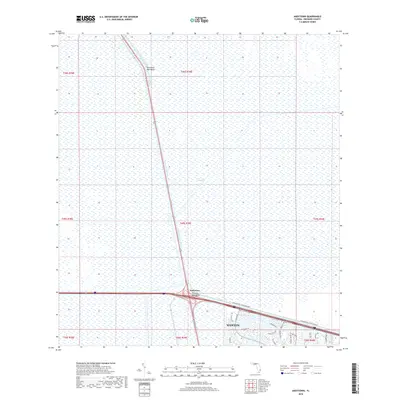
2018 Map of Andytown
USGS Topo · Published 2018About this map
The Everglades dominate this 2018 landscape, showing the transition between the vast conservation wetlands and the expanding suburban edge of Broward County. The North New River Canal cuts a straight path through the marshland, serving as a primary water management feature that historically defined movement and drainage in this part of Florida. At the junction of major transit corridors sits Andytown, a location marked by the prominent Twentysix Mile Bend. To the south, the development of Weston is clearly visible, with its intricate network of residential streets such as Indian Trce and Glades Pkwy pressing right against the Conservation Levee Greenway. This map captures the stark boundary where managed wilderness meets the modern planned community, providing a clear record of the region's environmental and urban boundaries.
Find a feature on this map
29 named features on this map. Tap any name to fly to it.
Don’t see what you’re looking for? This feature index may not catch every label — zoom into the map to look around manually.
Map Details
Editions of this 2018 Andytown Map
This is the sole edition of this map. No revisions or reprints were ever made.
Other maps of this area

1956 · West Palm Beach
USGS Topo · 1:250,000

1957 · West Palm Beach
USGS Topo · 1:250,000

1958 · West Palm Beach
USGS Topo · 1:250,000

1963 · Andytown
USGS Topo · 1:24,000

1963 · Cooper City SW
USGS Topo · 1:24,000

1963 · Fort Lauderdale 2 SE
USGS Topo · 1:24,000
1963 · Cooper City NE
USGS Topo · 1:24,000
1963 · Cooper City
USGS Topo · 1:24,000

1973 · Everglades 4 NE
USGS Topo · 1:24,000

1973 · Everglades 4 SE
USGS Topo · 1:24,000