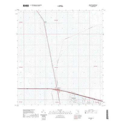
2021 Map of Andytown
USGS Topo · Published 2021About this map
The Everglades dominate the landscape of this contemporary Broward County survey, illustrating the managed intersection of wild marshland and modern suburban development. The North New River Canal cuts a sharp line across the terrain, serving as a primary water management artery alongside the Conservation Levee Trl. At the junction of these major corridors lies Andytown, situated near the distinctive Twentysix Mile Bend. To the southeast, the planned community of Weston begins its westward expansion into the sawgrass, with its network of residential streets such as Glades Pkwy and Falls Blvd pressing against the protected conservation areas. This map provides a clear record of the boundary between south Florida's urban frontier and the preserved wetlands, showing how infrastructure like the Conservation Levee - US27 Trl separates dense neighborhood developments from the expansive natural system to the west.
Find a feature on this map
31 named features on this map. Tap any name to fly to it.
Don’t see what you’re looking for? This feature index may not catch every label — zoom into the map to look around manually.
Map Details
Editions of this 2021 Andytown Map
This is the sole edition of this map. No revisions or reprints were ever made.
Other maps of this area

1956 · West Palm Beach
USGS Topo · 1:250,000

1957 · West Palm Beach
USGS Topo · 1:250,000

1958 · West Palm Beach
USGS Topo · 1:250,000

1963 · Andytown
USGS Topo · 1:24,000

1963 · Cooper City SW
USGS Topo · 1:24,000

1963 · Fort Lauderdale 2 SE
USGS Topo · 1:24,000
1963 · Cooper City NE
USGS Topo · 1:24,000
1963 · Cooper City
USGS Topo · 1:24,000

1973 · Everglades 4 NE
USGS Topo · 1:24,000

1973 · Everglades 4 SE
USGS Topo · 1:24,000