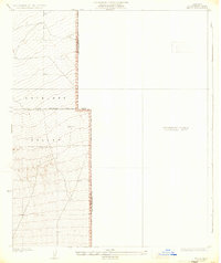
1932 Map of Angle
USGS Topo · Published 1933About this map
Antelope Valley transitions from surveyed terrain to a designated Preliminary Edition Unsurveyed Area in this early 1930s study. The map focuses on the eastern edge of the High Desert, where the border between Los Angeles Co and San Bernardino Co is defined by a north-south line. This specific quadrangle, prepared under County Surveyor J.E. Rockhold, reveals the early infrastructure of the region, including a solitary Well that suggests the critical importance of water for early settlement in this arid environment. The presence of the First Standard Parallel North provides a foundational surveying reference point, dividing the township and range system as the region was first being formalized for land ownership and management. The lack of detailed topography in the eastern half highlights the sparse, undeveloped nature of the area at the time of the 1930 survey.
Find a feature on this map
5 named features on this map. Tap any name to fly to it.
Don’t see what you’re looking for? This feature index may not catch every label — zoom into the map to look around manually.
Map Details
Editions of this 1932 Angle Map
2 editions found
Other maps of this area

1901 · Southern California Sheet No. 1
USGS Topo · 1:250,000

1903 · San Antonio
USGS Topo · 1:62,500

1904 · Southern California Sheet No. 1
USGS Topo · 1:250,000

1930 · Black Butte
USGS Topo · 1:24,000

1930 · El Mirage
USGS Topo · 1:24,000

1930 · Angle
USGS Topo · 1:24,000

1930 · Wilsona
USGS Topo · 1:24,000

1932 · Angle
USGS Topo · 1:24,000

1933 · El Mirage
USGS Topo · 1:24,000

1933 · Black Butte
USGS Topo · 1:24,000