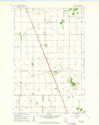
1961 Map of Angus
USGS Topo · Published 1963About this map
The Great Northern railroad cuts a straight, diagonal path across this section of Polk County, anchoring the small settlement of Angus. This early 1960s survey illustrates a landscape primarily defined by the rectilinear grid of township and range lines, where townships like Brislet, Euclid, and Helgeland meet. The terrain is notably flat, typical of the Red River Valley, with agricultural land use punctuated by localized industry and community landmarks. Researchers will find the St Pauls Cem in the southwestern corner within Keystone township. Near the eastern boundary, several Gravel Pits and a Gravel Pit indicate the extraction of glacial deposits, providing a specific look at the local economy and geology of the era before modern land reclamation.
Find a feature on this map
13 named features on this map. Tap any name to fly to it.
Don’t see what you’re looking for? This feature index may not catch every label — zoom into the map to look around manually.
Map Details
Editions of this 1961 Angus Map
This is the sole edition of this map. No revisions or reprints were ever made.
Other maps of this area

1918 · Angus
USGS Topo · 1:62,500

1918 · Warren
USGS Topo · 1:62,500

1952 · Grand Forks
USGS Topo · 1:250,000

1952 · Thief River Falls
USGS Topo · 1:250,000

1953 · Crookston
USGS Topo · 1:62,500

1955 · Warren
USGS Topo · 1:62,500

1956 · Thief River Falls
USGS Topo · 1:250,000

1956 · Grand Forks
USGS Topo · 1:250,000

1957 · Thief River Falls
USGS Topo · 1:250,000

1961 · Radium
USGS Topo · 1:24,000