
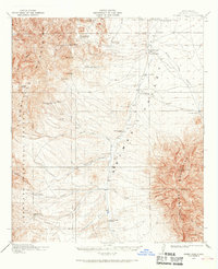
1918 Map of Animas Peak
USGS Topo · Published 1963About this map
High desert ranching life in the corner of New Mexico is meticulously documented here during the late 1910s. The Animas Valley separates two prominent ranges, with the Peloncillo Mountains to the west and the Animas Mountains rising to the east, capped by Animas Peak. This landscape is defined by its scattered homesteads and water sources, including Mavrick Spr and drainage systems like Horse Camp Draw and Bercham Draw.
Find a feature on this map
53 named features on this map. Tap any name to fly to it.
Don’t see what you’re looking for? This feature index may not catch every label — zoom into the map to look around manually.
Map Details
Editions of this 1918 Animas Peak Map
2 editions found
Other maps of this area

1917 · Chiricahua
USGS Topo · 1:125,000

1917 · Antelope Wells
USGS Topo · 1:62,500

1918 · Walnut Wells
USGS Topo · 1:62,500

1918 · Cienega Springs
USGS Topo · 1:62,500

1918 · Playas
USGS Topo · 1:62,500

1918 · Pratt
USGS Topo · 1:62,500

1919 · Pratt
USGS Topo · 1:62,500

1919 · Playas
USGS Topo · 1:62,500

1919 · Antelope Wells
USGS Topo · 1:62,500

1919 · Perilla
USGS Topo · 1:125,000