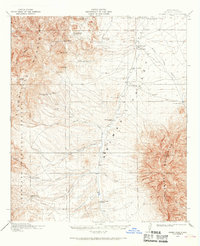
1918 Map of Animas Peak
USGS Topo · Published 1968About this map
The Animas Valley was a landscape defined by scattered ranching claims and intermittent water sources during this late-teens survey. Cattle operations dominate the region, with family names marking the map at the Old Isaacs Place, Eaton Place, and the Upper Lovett Place. These remote outposts relied on crucial water points like Middle Wells and Horse Camp Wells to sustain livestock between the Peloncillo Mountains to the west and the massive Animas Peak to the east.
Find a feature on this map
50 named features on this map. Tap any name to fly to it.
Don’t see what you’re looking for? This feature index may not catch every label — zoom into the map to look around manually.
Map Details
Editions of this 1918 Animas Peak Map
2 editions found
Other maps of this area

1917 · Chiricahua
USGS Topo · 1:125,000

1917 · Antelope Wells
USGS Topo · 1:62,500

1918 · Walnut Wells
USGS Topo · 1:62,500

1918 · Cienega Springs
USGS Topo · 1:62,500

1918 · Playas
USGS Topo · 1:62,500

1918 · Animas Peak
USGS Topo · 1:62,500

1918 · Pratt
USGS Topo · 1:62,500

1919 · Pratt
USGS Topo · 1:62,500

1919 · Playas
USGS Topo · 1:62,500

1919 · Antelope Wells
USGS Topo · 1:62,500