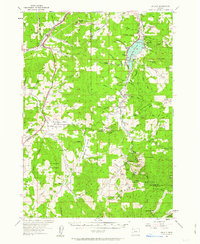
1954 Map of Anlauf
USGS Topo · Published 1963About this map
The Calapooya Divide defines the southern reach of this mid-century survey, separating the drainages of the Willamette River from the Umpqua system. The landscape is marked by a deep-rooted mining and timber economy, evidenced by the Black Butte Mine near Black Butte and the Elkhead Mines further west. In the northern section, the Southern Pacific railroad follows the winding path of the Pacific Highway through the small settlements of Comstock, Curtin, and Anlauf. Along the banks of the Coast Fork Willamette River, the rural community of London Springs serves as a hub for local life, featuring the London School, Hebron Church, and the London Cemetery. A unique piece of local heritage is recorded near the highway, where an Indian Burial Ground is noted on the terrain, while further south, the Shingle Mill on Elk Creek points to the area's industrial reliance on the surrounding timber-rich buttes.
Find a feature on this map
101 named features on this map. Tap any name to fly to it.
Don’t see what you’re looking for? This feature index may not catch every label — zoom into the map to look around manually.
Map Details
Editions of this 1954 Anlauf Map
3 editions found
Other maps of this area

1897 · Roseburg
USGS Topo · 1:125,000

1900 · Roseburg
USGS Topo · 1:125,000

1921 · Cottage Grove
USGS Topo · 1:62,500

1935 · Lowell
USGS Topo · 1:96,000

1942 · Lowell
USGS Topo · 1:125,000

1942 · Crow
USGS Topo · 1:62,500

1945 · Crow
USGS Topo · 1:62,500

1954 · Sutherlin
USGS Topo · 1:62,500

1954 · Drain
USGS Topo · 1:62,500

1954 · Anlauf
USGS Topo · 1:62,500