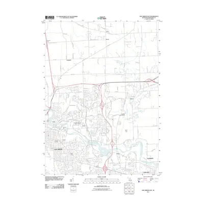
2011 Map of Ann Arbor East
USGS Topo · Published 2011About this map
Ann Arbor is depicted here as a major academic and cultural hub in the early twenty-first century, anchored by the extensive University of Michigan North Campus. The urban landscape is defined by its educational institutions and substantial green spaces, including the University of Michigan Botanical Gardens and Leslie Golf Course. For genealogists, the map is particularly detailed, pinpointing several historic burial grounds such as Forest Hill Cemetery and Saint Patricks Cemetery.
Find a feature on this map
50 named features on this map. Tap any name to fly to it.
Don’t see what you’re looking for? This feature index may not catch every label — zoom into the map to look around manually.
Map Details
Editions of this 2011 Ann Arbor East Map
This is the sole edition of this map. No revisions or reprints were ever made.
Other maps of this area

1902 · South Lyon
USGS Topo · 1:62,500

1902 · Ypsilanti
USGS Topo · 1:62,500

1902 · Dexter
USGS Topo · 1:62,500

1904 · Ann Arbor
USGS Topo · 1:125,000

1906 · Ypsilanti
USGS Topo · 1:62,500

1906 · Dexter
USGS Topo · 1:62,500

1906 · Saline
USGS Topo · 1:62,500

1906 · South Lyon
USGS Topo · 1:62,500

1908 · Ann Arbor
USGS Topo · 1:125,000
1936 · Denton
USGS Topo · 1:31,680
Featured Places
- Ann Arbor, MI
- Ypsilanti Charter Township, MI
- Pittsfield Charter Township, MI
- Ypsilanti, MI
- Superior Charter Township, MI