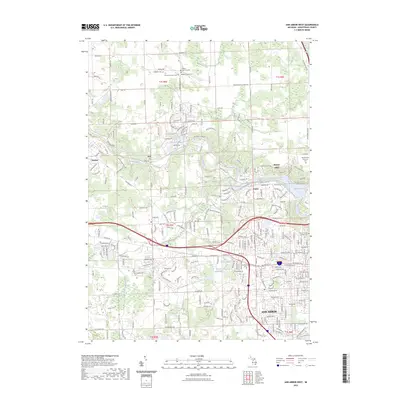
2023 Map of Ann Arbor West
USGS Topo · Published 2023About this map
Huron River dominates the center of this landscape, winding past the village of Dexter and into the reservoir at Barton Pond. This contemporary survey of the western periphery of Ann Arbor reveals a mix of dense residential planning and enduring rural history. Local historians can trace several significant burial grounds and religious sites, including the Webster Church area and the sprawling Washtenong Memorial Park. The map documents the geographical relationship between the city's growth and established settlements like Barton Hills and Foster. Significant water features such as First Sister Lake and Second Sister Lake are preserved near the municipal center, while the outer township lines of t1s r5e and t2s r6e define the transition from urban neighborhoods to the more open spaces of Scio.
Find a feature on this map
207 named features on this map. Tap any name to fly to it.
Don’t see what you’re looking for? This feature index may not catch every label — zoom into the map to look around manually.
Map Details
Editions of this 2023 Ann Arbor West Map
This is the sole edition of this map. No revisions or reprints were ever made.
Other maps of this area

1902 · South Lyon
USGS Topo · 1:62,500

1902 · Ypsilanti
USGS Topo · 1:62,500

1902 · Dexter
USGS Topo · 1:62,500

1904 · Ann Arbor
USGS Topo · 1:125,000

1906 · Ypsilanti
USGS Topo · 1:62,500

1906 · Dexter
USGS Topo · 1:62,500

1906 · Saline
USGS Topo · 1:62,500

1906 · South Lyon
USGS Topo · 1:62,500

1908 · Ann Arbor
USGS Topo · 1:125,000

1954 · Detroit
USGS Topo · 1:250,000
Featured Places
- Ann Arbor, MI
- Pittsfield Charter Township, MI
- Scio Township, MI
- Northfield Township, MI
- Webster Township, MI