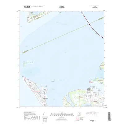
2018 Map of Anna Maria
USGS Topo · Published 2018About this map
Anna Maria Island defines the western edge of this coastal survey, where the settlements of Anna Maria and Holmes Beach face the open Gulf of Mexico. The landscape is a complex of keys and sounds, with Anna Maria Sound and Perico Bayou separating the barrier islands from the mainland near Bradenton. Cultural and historical markers are prominent, including the De Soto National Memorial at the mouth of the Manatee River and the Portavant Indian Mound on Snead Island. To the north, the massive Sunshine Skyway spans the entrance to Tampa Bay, while the northern reaches include protected areas like the Passage Key National Wildlife Refuge and the historic site of Fort De Soto on Mullet Key. This 2018 data illustrates the modern street grids of coastal communities alongside preserved estuarine environments.
Find a feature on this map
90 named features on this map. Tap any name to fly to it.
Don’t see what you’re looking for? This feature index may not catch every label — zoom into the map to look around manually.
Map Details
Editions of this 2018 Anna Maria Map
This is the sole edition of this map. No revisions or reprints were ever made.
Other maps of this area

1921 · Fort De Soto
USGS Topo · 1:62,500

1942 · Cockroach Bay
USGS Topo · 1:31,680

1943 · Pass-A-Grille
USGS Topo · 1:31,680

1944 · Egmont Key
USGS Topo · 1:31,680

1944 · Anna Maria
USGS Topo · 1:31,680

1944 · Ellenton
USGS Topo · 1:31,680

1944 · Bradenton Beach
USGS Topo · 1:31,680

1945 · Cockroach Bay
USGS Topo · 1:31,680
1947 · Cockroach Bay
USGS Topo · 1:25,000

1947 · Bradenton
USGS Topo · 1:24,000