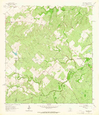
1963 Map of Anna Rose
USGS Topo · Published 1964About this map
Ramirena Creek and its many tributaries, including Kentuck Creek and Lagarto Creek, wind through this South Texas landscape where Live Oak, Jim Wells, and Duval counties meet. The settlement of Anna Rose serves as a central landmark in a region defined by ranching and resource extraction in the early 1960s. The map captures an active industrial footprint with numerous Oil Well sites and a Drill Hole scattered across the Ramirena Field and Amargosa Field. Water management is a primary feature of the local geography, evidenced by a dense network of family and place-named landmarks such as Lagarto Windmill, Patterson Windmill, and Calabaza Windmill. For researchers, the presence of smaller holdings like Freeborn Ranch and Rancho de la Parrita, alongside several scattered Grave and Cem markers, provides specific points of interest for tracing local family history and land use patterns during this era.
Find a feature on this map
25 named features on this map. Tap any name to fly to it.
Don’t see what you’re looking for? This feature index may not catch every label — zoom into the map to look around manually.
Map Details
Editions of this 1963 Anna Rose Map
2 editions found
Other maps of this area

1920 · Mikeska
USGS Topo · 1:125,000

1920 · San Diego
USGS Topo · 1:62,500

1953 · Crystal City
USGS Topo · 1:250,000

1955 · Crystal City
USGS Topo · 1:250,000

1956 · Rosita Ranch
USGS Topo · 1:62,500

1956 · Laredo
USGS Topo · 1:250,000

1961 · Crystal City
USGS Topo · 1:250,000

1963 · San Diego NE
USGS Topo · 1:24,000
1963 · Crater Ridge
USGS Topo · 1:24,000
1963 · Shaeffer Ranch
USGS Topo · 1:24,000