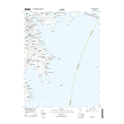
2014 Map of Annapolis
USGS Topo · Published 2014About this map
Annapolis and its waterfront neighborhoods dominate this coastal survey, where the Severn River meets the Chesapeake Bay. The maritime character of the Maryland capital is evident in the dense concentration of docks and coves, from the Naval Academy campus and Santee Basin to the residential expansion across Eastport and Annapolis Neck. The map provides a detailed view of the city's institutional footprint, including the grounds of St John's Coll and the historic Bloomsbury Square. North of the river, the landscape transitions to suburban developments like Ferry Farms and Wardour, while the massive spans of the United States Naval Academy Bridge and the William Preston Lane Junior Memorial Bridge emphasize the area's role as a vital transportation corridor. To the south, the intricate shoreline of Hillsmere Shores and Bay Ridge highlights the region's continued shift toward high-density waterfront living and recreational boating.
Find a feature on this map
157 named features on this map. Tap any name to fly to it.
Don’t see what you’re looking for? This feature index may not catch every label — zoom into the map to look around manually.
Map Details
Editions of this 2014 Annapolis Map
This is the sole edition of this map. No revisions or reprints were ever made.
Other maps of this area

1892 · Owensville
USGS Topo · 1:62,500

1892 · Annapolis
USGS Topo · 1:62,500

1893 · North Point
USGS Topo · 1:62,500

1894 · Relay
USGS Topo · 1:62,500

1895 · Owensville
USGS Topo · 1:62,500

1898 · Choptank
USGS Topo · 1:125,000

1898 · Tolchester
USGS Topo · 1:125,000

1899 · Patuxent
USGS Topo · 1:125,000

1903 · Tolchester
USGS Topo · 1:125,000

1904 · North Point
USGS Topo · 1:62,500