
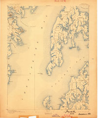
1892 Map of Annapolis
USGS Topo · Published 1892About this map
Annapolis serves as the focal point for this late nineteenth-century survey, shown alongside the expansion of Eastport and the resort character of Bay Ridge. The map documents a critical period for the regional transport network, featuring the Annapolis Wash. and Balt. R.R. terminating at the harbor. Across the Chesapeake Bay, the landscape of Queen Anne and Talbot counties is defined by an intricate network of necks and coves, including Bats Neck and Crab Alley Neck.
Find a feature on this map
76 named features on this map. Tap any name to fly to it.
Don’t see what you’re looking for? This feature index may not catch every label — zoom into the map to look around manually.
Map Details
Editions of this 1892 Annapolis Map
2 editions found
Other maps of this area

1892 · Prince Frederick
USGS Topo · 1:62,500

1892 · Owensville
USGS Topo · 1:62,500

1893 · Sharps Island
USGS Topo · 1:62,500

1893 · North Point
USGS Topo · 1:62,500

1894 · Relay
USGS Topo · 1:62,500

1895 · Prince Frederick
USGS Topo · 1:62,500

1895 · Owensville
USGS Topo · 1:62,500

1898 · Choptank
USGS Topo · 1:125,000

1898 · Tolchester
USGS Topo · 1:125,000

1899 · Patuxent
USGS Topo · 1:125,000