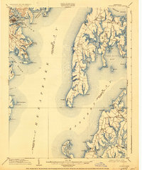
1904 Map of Annapolis
USGS Topo · Published 1930About this map
Annapolis and the Naval Academy sit at the mouth of the Severn River in this early-century survey of the Maryland coast. The map highlights the maritime connectivity of the era, from the residential shoreline of Eastport and the summer resort character of Bay Ridge to the sprawling landmass of Kent Island. The Queen Anne R. R. terminates at the water's edge in Claiborne, illustrating the vital link between rail transport and the steamboat ferries that bridged the bay.
Find a feature on this map
92 named features on this map. Tap any name to fly to it.
Don’t see what you’re looking for? This feature index may not catch every label — zoom into the map to look around manually.
Map Details
Editions of this 1904 Annapolis Map
5 editions found

Other maps of this area

1892 · Prince Frederick
USGS Topo · 1:62,500

1892 · Owensville
USGS Topo · 1:62,500

1892 · Annapolis
USGS Topo · 1:62,500

1893 · Sharps Island
USGS Topo · 1:62,500

1893 · North Point
USGS Topo · 1:62,500

1894 · Relay
USGS Topo · 1:62,500

1895 · Prince Frederick
USGS Topo · 1:62,500

1895 · Owensville
USGS Topo · 1:62,500

1898 · Choptank
USGS Topo · 1:125,000

1898 · Tolchester
USGS Topo · 1:125,000