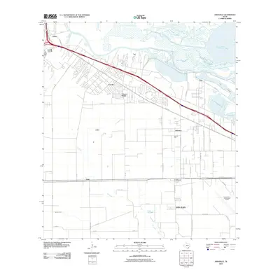
2010 Map of Annaville
USGS Topo · Published 2010About this map
Annaville and the surrounding coastal plain of Nueces County appear here at a moment of significant suburban and industrial transition. The landscape is defined by the winding course of the Nueces River as it opens toward Nueces Bay, with the heavy industrial infrastructure of the Viola Channel and Tule Lake marking the eastern edge near Viola. To the south, the grid-like agricultural blocks are punctuated by established settlements like Violet and Clarkwood, while the Saxet Oil Field indicates the region's long-standing energy industry. Transport corridors like the Joe Fulton Corridor and I-37 cut through the terrain, connecting residential developments such as Arlington Heights with the commercial hubs of Calallen and McNorton. The presence of the Corpus Christi International Airport in the southeast corner underscores the area's role as a modern regional gateway, contrasting with the smaller, localized communities found along the Oso Creek drainage.
Find a feature on this map
57 named features on this map. Tap any name to fly to it.
Don’t see what you’re looking for? This feature index may not catch every label — zoom into the map to look around manually.
Map Details
Editions of this 2010 Annaville Map
This is the sole edition of this map. No revisions or reprints were ever made.
Other maps of this area

1924 · Petronilla
USGS Topo · 1:62,500

1925 · Robstown
USGS Topo · 1:62,500

1925 · Oso Creek
USGS Topo · 1:62,500

1925 · Corpus Christi
USGS Topo · 1:62,500

1950 · Corpus Christi
USGS Topo · 1:250,000

1951 · Corpus Christi
USGS Topo · 1:24,000

1951 · Corpus Christi
USGS Topo · 1:62,500

1951 · Oso Creek NW
USGS Topo · 1:24,000

1951 · Oso Creek
USGS Topo · 1:62,500

1954 · Robstown
USGS Topo · 1:62,500
Featured Places
- Corpus Christi, TX
- Clarkwood, Corpus Christi
- Violet, TX
- McNorton, Corpus Christi
- San Juan, Corpus Christi