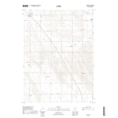
2017 Map of Anselmo
USGS Topo · Published 2017About this map
Anselmo serves as the primary hub in this portion of Custer County, situated along a prominent rail line that cuts diagonally across the landscape. The town's grid, including N Baxter St and E Owen Ave, transitions into a wide-ranging network of section roads that navigate the surrounding valleys and canyons. This 2017 survey reveals a rural landscape defined by geographic features such as New Hope Valley, Dale Valley, and Ortello Valley, interspersed with long-standing community landmarks. Genealogists will find several notable burial sites throughout the townships, including Saint Anselms Cem near the main settlement, as well as the more remote New Hope Cem and Dale Cem. Water management is evident in the northeast near New Helena, where Sargent Reservoir and Cedar Lake are fed by the waters of Victoria Cr, illustrating the vital role of these drainage systems in Nebraska's agricultural heartland.
Find a feature on this map
34 named features on this map. Tap any name to fly to it.
Don’t see what you’re looking for? This feature index may not catch every label — zoom into the map to look around manually.
Map Details
Editions of this 2017 Anselmo Map
This is the sole edition of this map. No revisions or reprints were ever made.
Other maps of this area

1951 · Lillian
USGS Topo · 1:24,000

1951 · Callaway NW
USGS Topo · 1:24,000

1951 · Anselmo
USGS Topo · 1:24,000

1951 · Broken Bow
USGS Topo · 1:24,000

1951 · Merna
USGS Topo · 1:24,000

1951 · Anselmo SW
USGS Topo · 1:24,000

1951 · Anselmo NE
USGS Topo · 1:24,000

1951 · Anselmo NW
USGS Topo · 1:24,000

1951 · Milburn
USGS Topo · 1:24,000

1955 · Broken Bow
USGS Topo · 1:250,000