
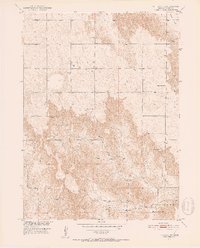
1951 Map of Callaway NW
USGS Topo · Published 1952About this map
Ortello Valley and the surrounding tablelands of Custer County reflect a mid-century landscape of rural education and dispersed farming. The map reveals a remarkably dense network of country schools, such as Center Sch, Fairview Sch, and Maple Grove Sch, spaced to serve a community tied to the land. This distribution of small schoolhouses, including Sunflower Sch and Highland Sch, suggests a persistent rural population density prior to the consolidation of modern school districts. Spring Creek cuts through the southern reaches, where Upper Spring Creek Sch stands near the transition into the Ryno and Triumph areas. The presence of Cliff Ch and its associated Cem underscores the importance of local religious and social centers in this pocket of the Nebraska plains, while the varied terrain of Table and Cliffs defines the physical character of the high prairies.
Find a feature on this map
18 named features on this map. Tap any name to fly to it.
Don’t see what you’re looking for? This feature index may not catch every label — zoom into the map to look around manually.
Map Details
Editions of this 1951 Callaway NW Map
2 editions found
Other maps of this area

1948 · Linscott
USGS Topo · 1:62,500

1950 · Linscott
USGS Topo · 1:62,500

1951 · Anselmo
USGS Topo · 1:24,000

1951 · Merna
USGS Topo · 1:24,000

1951 · Anselmo SW
USGS Topo · 1:24,000

1951 · Callaway SE
USGS Topo · 1:24,000

1951 · Callaway
USGS Topo · 1:24,000

1954 · North Platte
USGS Topo · 1:250,000

1955 · Broken Bow
USGS Topo · 1:250,000

1956 · Broken Bow
USGS Topo · 1:250,000