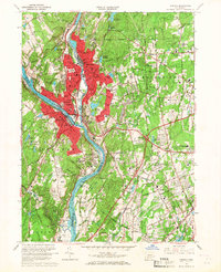
1964 Map of Ansonia
USGS Topo · Published 1967About this map
The Naugatuck River joins the Housatonic River at the industrial heart of this valley, where the urban centers of Ansonia, Derby, and Shelton form a dense cluster of post-war development. The landscape reveals a transition from high-density residential blocks and civic landmarks like the City Hall and Armory to the emerging suburban patterns in Woodbridge and Orange. Significant land use includes the Osborndale State Park and the sprawling grounds of the Laurel Heights State Sanatarium.
Find a feature on this map
104 named features on this map. Tap any name to fly to it.
Don’t see what you’re looking for? This feature index may not catch every label — zoom into the map to look around manually.
Map Details
Editions of this 1964 Ansonia Map
4 editions found
Other maps of this area

1889 · Derby
USGS Topo · 1:62,500

1891 · Bridgeport
USGS Topo · 1:62,500

1891 · Derby
USGS Topo · 1:62,500

1892 · New Haven
USGS Topo · 1:62,500

1893 · Bridgeport
USGS Topo · 1:62,500

1893 · Derby
USGS Topo · 1:62,500

1920 · Bridgeport
USGS Topo · 1:62,500

1921 · New Haven
USGS Topo · 1:62,500

1943 · New Haven
USGS Topo · 1:31,680

1943 · Naugatuck
USGS Topo · 1:31,680