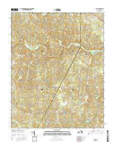
2016 Map of Ante
USGS Topo · Published 2016About this map
The Meherrin River meanders across this landscape of southern Virginia, defining the boundary-heavy terrain where small settlements and family holdings have persisted for generations. This survey reflects the rural character of the region, anchored by the community of Ante and the riverside location of Webbs Mill. The map is particularly useful for genealogists, as it identifies numerous family-named burial sites including the Phillips Cem, Powell Cem, and Bowen Cem. North of the river, the settlement of Totaro sits near the New Hope Zion Cem, while the eastern portion of the sheet transitions across the Brunswick and Greensville county line. Roadways like Halifax Rd and Dry Bread Rd trace historical paths through a landscape of creeks and pond systems, including Doyle Lake and Mitchells Pond.
Find a feature on this map
61 named features on this map. Tap any name to fly to it.
Don’t see what you’re looking for? This feature index may not catch every label — zoom into the map to look around manually.
Map Details
Editions of this 2016 Ante Map
This is the sole edition of this map. No revisions or reprints were ever made.
Other maps of this area

1918 · Lawrenceville
USGS Topo · 1:62,500

1919 · Mc Kenney
USGS Topo · 1:48,000

1919 · White Plains
USGS Topo · 1:48,000

1919 · Emporia
USGS Topo · 1:62,500

1920 · Lawrenceville
USGS Topo · 1:48,000

1920 · White Plains
USGS Topo · 1:62,500

1921 · Mc Kenney
USGS Topo · 1:62,500

1921 · Lawrenceville
USGS Topo · 1:62,500

1942 · Lawrenceville
USGS Topo · 1:62,500

1942 · Emporia
USGS Topo · 1:62,500