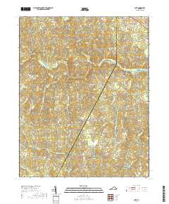
2019 Map of Ante
USGS Topo · Published 2019About this map
The Meherrin River meanders across this Southside Virginia landscape, defining the boundary between Brunswick and Greensville counties near the crossroads of Ante. This modern survey records a rural landscape shaped by long-standing family ties and small agricultural settlements. The land is punctuated by numerous family and community burial grounds, including the Cordle Cem, Powell Cem, and New Hope Zion Cem, providing essential points of reference for genealogical research in this region.
Find a feature on this map
64 named features on this map. Tap any name to fly to it.
Don’t see what you’re looking for? This feature index may not catch every label — zoom into the map to look around manually.
Map Details
Editions of this 2019 Ante Map
This is the sole edition of this map. No revisions or reprints were ever made.
Other maps of this area

1918 · Lawrenceville
USGS Topo · 1:62,500

1919 · Mc Kenney
USGS Topo · 1:48,000

1919 · White Plains
USGS Topo · 1:48,000

1919 · Emporia
USGS Topo · 1:62,500

1920 · Lawrenceville
USGS Topo · 1:48,000

1920 · White Plains
USGS Topo · 1:62,500

1921 · Mc Kenney
USGS Topo · 1:62,500

1921 · Lawrenceville
USGS Topo · 1:62,500

1942 · Lawrenceville
USGS Topo · 1:62,500

1942 · Emporia
USGS Topo · 1:62,500