
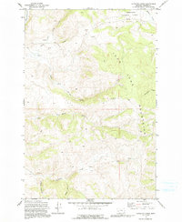
1971 Map of Antelope Creek
USGS Topo · Published 1973About this map
The John Long Mountains define the high country of Granite County in this early 1970s study, much of which is protected within the Deerlodge National Forest. This high-altitude landscape is deeply incised by a network of seasonal and perennial watercourses, including Antelope Creek, Upper Willow Creek, and the curiously named Bathhouse Creek. The drainage patterns, particularly along Spring Creek and its various forks, suggest a terrain shaped by snowmelt and spring runoff common to this part of Montana.
Find a feature on this map
17 named features on this map. Tap any name to fly to it.
Don’t see what you’re looking for? This feature index may not catch every label — zoom into the map to look around manually.
Map Details
Editions of this 1971 Antelope Creek Map
2 editions found
Other maps of this area

1908 · Philipsburg
USGS Topo · 1:125,000

1909 · Sapphire
USGS Topo · 1:125,000

1947 · Butte
USGS Topo · 1:250,000

1958 · Butte
USGS Topo · 1:250,000

1960 · Butte
USGS Topo · 1:250,000

1962 · Butte
USGS Topo · 1:250,000

1971 · Henderson Mountain
USGS Topo · 1:24,000

1971 · Georgetown Lake
USGS Topo · 1:24,000

1971 · Potato Lakes
USGS Topo · 1:24,000
1971 · Philipsburg
USGS Topo · 1:24,000