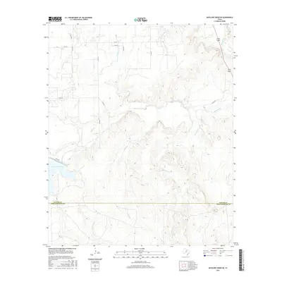
2016 Map of Antelope Creek NE
USGS Topo · Published 2016About this map
Millers Cr Reservoir dominates the southwestern portion of this landscape, where the waters of Mexican Cr and Millers Cr meet. This 2016 survey illustrates the intricate drainage network across the Baylor and Throckmorton county line, defined by seasonal runs and creek beds like Louse Run and Gray Back Cr that carve through the local topography. In the northeast, the Brazos River cuts a distinct path, flanked by a network of county roads including Co RD 449 and Co RD 445. The map provides a clear picture of rural Texas infrastructure, showing the intersection of FM 2395 and several local routes that service the ranching and agricultural lands between the reservoir and the river basin.
Find a feature on this map
25 named features on this map. Tap any name to fly to it.
Don’t see what you’re looking for? This feature index may not catch every label — zoom into the map to look around manually.
Map Details
Editions of this 2016 Antelope Creek NE Map
This is the sole edition of this map. No revisions or reprints were ever made.
Other maps of this area

1954 · Wichita Falls
USGS Topo · 1:250,000

1958 · Wichita Falls
USGS Topo · 1:250,000

1962 · Antelope Creek SW
USGS Topo · 1:24,000

1962 · Antelope Creek SE
USGS Topo · 1:24,000

1962 · Antelope Creek NE
USGS Topo · 1:24,000

1962 · Antelope Creek NW
USGS Topo · 1:24,000

1966 · Seymour West
USGS Topo · 1:24,000

1966 · Rock Canyon
USGS Topo · 1:24,000

1966 · Westover SW
USGS Topo · 1:24,000

1966 · Bomarton
USGS Topo · 1:24,000