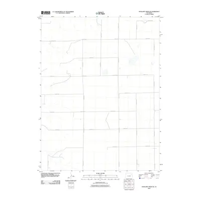
2010 Map of Antelope Creek SE
USGS Topo · Published 2010About this map
Antelope Creek meanders through this section of Washington County, defining the drainage patterns of an open, high-plains landscape. The area is characterized by a precise, rectangular grid of section-line roads, such as County Road Y and County Rd-18, which reflect the enduring legacy of the Public Land Survey System in eastern Colorado. This 2010 survey by the U.S. Geological Survey illustrates a sparsely populated agricultural or rangeland region where the primary infrastructure consists of these essential transit corridors like County Rd-20 and County Road AA. The mapping detail focuses on the subtle hydrography of the creek and several small, seasonal water bodies scattered across the terrain, offering a clear view of the rural geography just as it transitioned into the second decade of the twenty-first century.
Find a feature on this map
15 named features on this map. Tap any name to fly to it.
Don’t see what you’re looking for? This feature index may not catch every label — zoom into the map to look around manually.
Map Details
Editions of this 2010 Antelope Creek SE Map
This is the sole edition of this map. No revisions or reprints were ever made.
Other maps of this area

1954 · Limon
USGS Topo · 1:250,000

1957 · Limon
USGS Topo · 1:250,000

1958 · Limon
USGS Topo · 1:250,000

1973 · Antelope Creek East
USGS Topo · 1:24,000

1973 · Antelope Creek West
USGS Topo · 1:24,000

1973 · Dry Gulch
USGS Topo · 1:24,000

1973 · Lindon NE
USGS Topo · 1:24,000

1973 · Antelope Creek SE
USGS Topo · 1:24,000

1973 · Lindon
USGS Topo · 1:24,000
1974 · Elba
USGS Topo · 1:24,000