
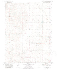
1973 Map of Antelope Creek East
USGS Topo · Published 1976About this map
Antelope Creek and Buck Creek define the drainage of this High Plains landscape in northeastern Colorado during the early 1970s. This survey records a remote agricultural and resource-extraction frontier where the vastness of the terrain is interrupted by the sparse infrastructure of the energy industry. Remnants of local community life and industry are preserved in labels for the Elba Cem and a small Gravel Pit. To the north, scattered Oil Wells and an isolated Oil Well reflect the region's mid-century petroleum development. The map is a precise document of land use, showing the network of unimproved roads and light-duty paths that connected these isolated sites across the county lines of Washington and Colorado.
Find a feature on this map
6 named features on this map. Tap any name to fly to it.
Don’t see what you’re looking for? This feature index may not catch every label — zoom into the map to look around manually.
Map Details
Editions of this 1973 Antelope Creek East Map
2 editions found
Other maps of this area

1954 · Limon
USGS Topo · 1:250,000

1954 · Sterling
USGS Topo · 1:250,000

1957 · Limon
USGS Topo · 1:250,000

1958 · Limon
USGS Topo · 1:250,000

1958 · Sterling
USGS Topo · 1:250,000

1973 · Antelope Creek West
USGS Topo · 1:24,000

1973 · Dry Gulch
USGS Topo · 1:24,000

1973 · Rago
USGS Topo · 1:24,000

1973 · Antelope Creek SE
USGS Topo · 1:24,000

1973 · Pinneo SE
USGS Topo · 1:24,000