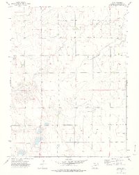
1974 Map of Elba
USGS Topo · Published 1978About this map
Elba stands as the primary reference point in this corner of Washington County, Colorado, during the mid-1970s. The landscape is defined by the winding course of Hell Creek, which carves through the undulating plains from the northwest to the northeast. This area illustrates the infrastructure of High Plains dryland farming, where individual agricultural viability is marked by the presence of numerous scattered wells and localized grain management sites like the Storage Bins and a singular Storage Bin located south of the main creek. The map captures the region after photogrammetric surveys in 1973, reflecting a period of established rural settlement where section lines dictate the road network and land use patterns. This survey is a focused study of the relationship between water resources and agricultural storage in a landscape where small-scale named features are sparse but significant to local operations.
Find a feature on this map
6 named features on this map. Tap any name to fly to it.
Don’t see what you’re looking for? This feature index may not catch every label — zoom into the map to look around manually.
Map Details
Editions of this 1974 Elba Map
This is the sole edition of this map. No revisions or reprints were ever made.
Other maps of this area

1954 · Limon
USGS Topo · 1:250,000

1954 · Sterling
USGS Topo · 1:250,000

1957 · Limon
USGS Topo · 1:250,000

1958 · Limon
USGS Topo · 1:250,000

1958 · Sterling
USGS Topo · 1:250,000

1973 · Antelope Creek East
USGS Topo · 1:24,000

1973 · Antelope Creek SE
USGS Topo · 1:24,000

1973 · Pinneo SE
USGS Topo · 1:24,000

1973 · Akron SE
USGS Topo · 1:24,000
1973 · Akron SW
USGS Topo · 1:24,000