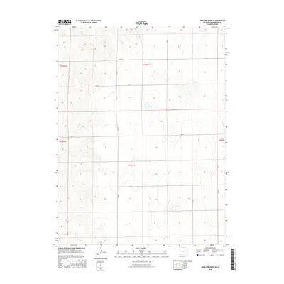
2016 Map of Antelope Creek SE
USGS Topo · Published 2016About this map
Antelope Creek defines the northern reaches of this rural Washington County landscape, carved by a system of section-line roads that reflect the rigid order of the Public Land Survey System. The terrain is a vast stretch of open range and agricultural allotments, where movement is dictated by a grid of county thoroughfares including Co Rd X, Co Rd W, and Co Rd 20. This 2016 survey documents the enduring pastoral character of the High Plains, where the drainage of the creek provides a rare break in the uniform topography. Modern land use is signaled by the presence of cattle tanks and seasonal wetlands, while the surrounding infrastructure like Co Rd AA and Co Rd U connects isolated farmsteads and ranching operations to the wider region. The map provides a precise record of late-period rural Colorado, showing the intersection of natural drainage and human organization in a sparsely populated environment.
Find a feature on this map
20 named features on this map. Tap any name to fly to it.
Don’t see what you’re looking for? This feature index may not catch every label — zoom into the map to look around manually.
Map Details
Editions of this 2016 Antelope Creek SE Map
This is the sole edition of this map. No revisions or reprints were ever made.
Other maps of this area

1954 · Limon
USGS Topo · 1:250,000

1957 · Limon
USGS Topo · 1:250,000

1958 · Limon
USGS Topo · 1:250,000

1973 · Antelope Creek East
USGS Topo · 1:24,000

1973 · Antelope Creek West
USGS Topo · 1:24,000

1973 · Dry Gulch
USGS Topo · 1:24,000

1973 · Lindon NE
USGS Topo · 1:24,000

1973 · Antelope Creek SE
USGS Topo · 1:24,000

1973 · Lindon
USGS Topo · 1:24,000
1974 · Elba
USGS Topo · 1:24,000