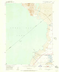
1952 Map of Antelope Island South
USGS Topo · Published 1958About this map
Saltair Resort stands as a prominent landmark on the southeastern shore of the Great Salt Lake, complete with its own roller coaster and infrastructure. This mid-century survey captures the industrial and recreational landscape along the lake's edge, where the Union Pacific railroad and the Garfield and Western Base Line traverse the salt flats. To the north, the southern tip of Antelope Island rises sharply with peaks like Mollys Nipple, contrasting with the vast, low-lying Salt Flat and salt evaporators to the east.
Find a feature on this map
28 named features on this map. Tap any name to fly to it.
Don’t see what you’re looking for? This feature index may not catch every label — zoom into the map to look around manually.
Map Details
Editions of this 1952 Antelope Island South Map
2 editions found
Other maps of this area

1885 · Tooele Valley
USGS Topo · 1:250,000

1951 · Saltair
USGS Topo · 1:24,000

1952 · Saltair NE
USGS Topo · 1:24,000

1952 · Magna
USGS Topo · 1:24,000

1952 · Antelope Island South
USGS Topo · 1:24,000

1952 · Garfield
USGS Topo · 1:24,000

1953 · Tooele
USGS Topo · 1:250,000

1954 · Antelope Island
USGS Topo · 1:24,000

1955 · Mills Junction
USGS Topo · 1:24,000

1955 · Tooele
USGS Topo · 1:250,000