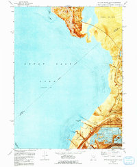
1972 Map of Antelope Island South
USGS Topo · Published 1992About this map
Antelope Island rises from the southern reaches of the Great Salt Lake, its southern tip defined by prominent landmarks like Mollys Nipple and Mcintyre Spring. The landscape transition from the high ground of the island down across the Alkali or Mud flats reveals a complex industrial and recreational history along the shoreline. In the early 1970s, the southeastern edge of the lake was a hub of activity centered around the Saltair Resort (Site) and Saltair Beach, where the legacy of rail transport is still visible through the Old Railroad Grade and other historic embankments. Further south, the map details the infrastructure of the Great Salt Lake's mineral industry, including extensive Salt Evaporators, a Tailings Pond, and the small settlement at Saltus. The mapping of an Aqueduct and various gaging stations highlights the management of water and salt resources in this unique environment.
Find a feature on this map
24 named features on this map. Tap any name to fly to it.
Don’t see what you’re looking for? This feature index may not catch every label — zoom into the map to look around manually.
Map Details
Editions of this 1972 Antelope Island South Map
2 editions found
Other maps of this area

1885 · Tooele Valley
USGS Topo · 1:250,000

1951 · Saltair
USGS Topo · 1:24,000

1952 · Saltair NE
USGS Topo · 1:24,000

1952 · Magna
USGS Topo · 1:24,000

1952 · Antelope Island South
USGS Topo · 1:24,000

1952 · Garfield
USGS Topo · 1:24,000

1953 · Tooele
USGS Topo · 1:250,000

1954 · Antelope Island
USGS Topo · 1:24,000

1955 · Mills Junction
USGS Topo · 1:24,000

1955 · Tooele
USGS Topo · 1:250,000