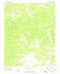
1971 Map of Antelope Lake
USGS Topo · Published 1975About this map
The Navajo Indian Reservation landscape in Apache County is defined by its drainage systems and infrastructure in the early 1970s. Arroyos and intermittent streams like Wide Wash and Antelope Wash shape the terrain, which rises toward Oak Ridge and drops into the depths of Pine Canyon. The presence of a Landing Strip, a prominent Pipeline, and a Pumping Station indicates the importance of transportation and resource management in this high-desert environment. Seasonal water sources such as Antelope Lake and Hidden Lake provide vital landmarks, while a Corral and several wells, including the Pine Canyon Well, point to the region's ranching activity and reliance on groundwater.
Find a feature on this map
12 named features on this map. Tap any name to fly to it.
Don’t see what you’re looking for? This feature index may not catch every label — zoom into the map to look around manually.
Map Details
Editions of this 1971 Antelope Lake Map
This is the sole edition of this map. No revisions or reprints were ever made.
Other maps of this area

1886 · Fort Defiance
USGS Topo · 1:250,000

1892 · Fort Defiance
USGS Topo · 1:250,000

1954 · Gallup
USGS Topo · 1:250,000

1955 · Zith-Tusayan Butte 3 NW
USGS Topo · 1:24,000

1955 · Zith-Tusayan Butte 4 NW
USGS Topo · 1:24,000

1955 · Zith-Tusayan Butte 3 NE
USGS Topo · 1:24,000

1958 · Gallup
USGS Topo · 1:250,000

1959 · Gallup
USGS Topo · 1:250,000

1962 · Gallup
USGS Topo · 1:250,000

1967 · Gallup
USGS Topo · 1:250,000