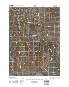
2011 Map of Antelope Mountain
USGS Topo · Published 2011About this map
Antelope Mountain rises above a high-altitude landscape defined by timber resources and scattered springs in this 2011 survey of Klamath County. The area is heavily marked by a network of forest service roads, including Natl Forest Develop Road 2726 Rd and Natl Forest Develop Road 2516 Rd, which provide access to the timber stands and ridges. The presence of Tobin Cabin suggests a history of local shelter for foresters or travelers in the vicinity of Timothy Butte. The terrain is characterized by broad flats and volcanic features, such as Antelope Flat and Rock Butte. Water sources like Jungle Spring and Antelope Spring appear as critical points in the dry upland environment, feeding small drainages like Timothy Creek and Rock Creek.
Find a feature on this map
16 named features on this map. Tap any name to fly to it.
Don’t see what you’re looking for? This feature index may not catch every label — zoom into the map to look around manually.
Map Details
Editions of this 2011 Antelope Mountain Map
This is the sole edition of this map. No revisions or reprints were ever made.
Other maps of this area

1955 · Crescent
USGS Topo · 1:250,000

1957 · Crescent
USGS Topo · 1:250,000

1958 · Crescent
USGS Topo · 1:250,000

1968 · Location Butte
USGS Topo · 1:24,000

1968 · Rodman Rock
USGS Topo · 1:24,000

1968 · Oatman Flat
USGS Topo · 1:24,000
1968 · Antelope Mtn
USGS Topo · 1:24,000
1968 · Bear Butte
USGS Topo · 1:24,000
1968 · Bridge Creek Draw
USGS Topo · 1:24,000

1970 · Crescent
USGS Topo · 1:250,000