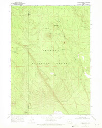
1968 Map of Antelope Mtn
USGS Topo · Published 1971About this map
Antelope Mountain dominates this high-country landscape within the Fremont National Forest, straddling the border of Klamath and Lake counties. This late-1960s survey documents a region defined by water management and resource extraction in the high desert, evidenced by the presence of a Cinder Pit and a network of remote water sources. Names like Tobin Cabin and Tobin Spring suggest early pioneer or ranching activity, while several points such as Timothy Well (Dry), Matts Well, and Glades Well highlight the critical nature of water security in this arid environment. The map details the transition from the timbered slopes of Timothy Butte down to the open expanse of Antelope Flat, providing a clear record of the forest boundaries and unimproved roads as they existed before modern developments reached this corner of Oregon.
Find a feature on this map
16 named features on this map. Tap any name to fly to it.
Don’t see what you’re looking for? This feature index may not catch every label — zoom into the map to look around manually.
Map Details
Editions of this 1968 Antelope Mtn Map
2 editions found
Other maps of this area

1955 · Crescent
USGS Topo · 1:250,000

1957 · Crescent
USGS Topo · 1:250,000

1958 · Crescent
USGS Topo · 1:250,000

1968 · Location Butte
USGS Topo · 1:24,000

1968 · Rodman Rock
USGS Topo · 1:24,000

1968 · Oatman Flat
USGS Topo · 1:24,000
1968 · Bear Butte
USGS Topo · 1:24,000
1968 · Bridge Creek Draw
USGS Topo · 1:24,000

1970 · Crescent
USGS Topo · 1:250,000

1979 · Crescent
USGS Topo · 1:100,000