1979 Map of Crescent
USGS Topo · Published 1994About this map
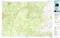
Walker Rim dominates the central landscape of this high-altitude region, where the volcanic geology of the Cascades meets the arid stretches of the eastern basin. In the late 1970s, the corridor of U S Highway 97 linked the small timber and rail-dependent communities of Gilchrist, Crescent, and Chemult. This map captures a transition point in the Oregon interior where the Deschutes National Forest and Winema National Forest give way to the striking geothermal features of the Antelope Desert.
Find a feature on this map
58 named features on this map. Tap any name to fly to it.
Don’t see what you’re looking for? This feature index may not catch every label — zoom into the map to look around manually.
Map Details
Editions of this 1979 Crescent Map
This is the sole edition of this map. No revisions or reprints were ever made.
Other maps of this area

1889 · Klamath
USGS Topo · 1:250,000

1891 · Ashland
USGS Topo · 1:250,000

1893 · Ashland
USGS Topo · 1:250,000

1894 · Klamath
USGS Topo · 1:250,000

1897 · Ashland
USGS Topo · 1:250,000

1917 · Diamond Lake
USGS Topo · 1:125,000

1925 · Waldo Lake
USGS Topo · 1:125,000

1930 · Maiden Peak
USGS Topo · 1:125,000

1931 · Newberry Crater
USGS Topo · 1:125,000

1934 · Maiden Peak
USGS Topo · 1:125,000