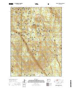
2020 Map of Antelope Mountain
USGS Topo · Published 2020About this map
Fremont National Forest defines the high-desert timberlands on this survey of the Klamath and Lake county borderlands. The landscape is dominated by high points such as Timothy Butte and Antelope Mtn, which rise above the expansive Antelope Flat. Water sources in this arid region are concentrated at specific points, including Mowich Spring, Jungle Spring, and Tobin Spring, which were vital markers for early stockmen and forest rangers. The course of Timothy Cr and Rock Cr cut through the terrain, illustrating the drainage patterns toward the southern reach of the quadrangle near Rock Butte. The network of forest roads and township lines reveals the methodical management of these public lands during the early twenty-first century, preserving a rugged portion of the Oregon backcountry for recreation and resource protection.
Find a feature on this map
16 named features on this map. Tap any name to fly to it.
Don’t see what you’re looking for? This feature index may not catch every label — zoom into the map to look around manually.
Map Details
Editions of this 2020 Antelope Mountain Map
This is the sole edition of this map. No revisions or reprints were ever made.
Other maps of this area

1955 · Crescent
USGS Topo · 1:250,000

1957 · Crescent
USGS Topo · 1:250,000

1958 · Crescent
USGS Topo · 1:250,000

1968 · Location Butte
USGS Topo · 1:24,000

1968 · Rodman Rock
USGS Topo · 1:24,000

1968 · Oatman Flat
USGS Topo · 1:24,000
1968 · Antelope Mtn
USGS Topo · 1:24,000
1968 · Bear Butte
USGS Topo · 1:24,000
1968 · Bridge Creek Draw
USGS Topo · 1:24,000

1970 · Crescent
USGS Topo · 1:250,000