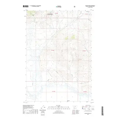
2020 Map of Antelope Peak
USGS Topo · Published 2020About this map
Antelope Peak stands as a prominent landmark within this high-elevation landscape of Beaverhead County, where the southern reaches of the Snowcrest Range meet the broad expanse of the Centennial Valley. The terrain is defined by a series of north-south drainages including Middle Cr, Loriot Cr, and Brundage Cr, which flow toward the meandering Red Rock River in the south. This 2020 survey illustrates a region dominated by public lands, with a significant portion of the north designated as part of the Beaverhead National Forest. Transportation across this remote ranching and conservation corridor is facilitated by a network of unimproved routes such as Ruby Divide Rd, N Valley Rd, and numerous Bureau of Land Management tracks like blmtc4. The map provides clear detail for researchers tracking land use and water rights along the many small tributaries that feed the Red Rock basin.
Find a feature on this map
28 named features on this map. Tap any name to fly to it.
Don’t see what you’re looking for? This feature index may not catch every label — zoom into the map to look around manually.
Map Details
Editions of this 2020 Antelope Peak Map
This is the sole edition of this map. No revisions or reprints were ever made.
Other maps of this area

1950 · Lower Red Rock Lake
USGS Topo · 1:62,500

1950 · Monument Ridge
USGS Topo · 1:62,500

1955 · Dubois
USGS Topo · 1:250,000

1955 · Ashton
USGS Topo · 1:250,000

1958 · Dubois
USGS Topo · 1:250,000

1958 · Ashton
USGS Topo · 1:250,000

1960 · Ashton
USGS Topo · 1:250,000

1968 · Stonehouse Mountain
USGS Topo · 1:24,000

1968 · Corral Creek
USGS Topo · 1:24,000

1968 · Big Table Mountain
USGS Topo · 1:24,000