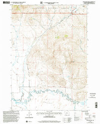
1997 Map of Antelope Peak
USGS Topo · Published 2002About this map
The Centennial Valley floor and the surrounding highlands of the Beaverhead National Forest dominate this landscape during the late twentieth century. A dramatic hydrologic divide is formed by the Centennial Divide, which separates the northern drainages like Plute Creek and Crow Creek from the expansive Red Rock River system to the south. The southern portion of the map is defined by the complex, meandering channels of the river as it feeds into the Lima Reservoir, where a Gaging Station monitors the vital water flow in this high-altitude basin. High points such as Antelope Peak and Lone Butte provide topographic anchors for the region, while the Centennial Divide Road serves as a primary corridor through the terrain. This survey captures the area after decades of established water management and forest service oversight, highlighting the tension between the serpentine river valley and the steep, wooded slopes of the Divide.
Find a feature on this map
21 named features on this map. Tap any name to fly to it.
Don’t see what you’re looking for? This feature index may not catch every label — zoom into the map to look around manually.
Map Details
Editions of this 1997 Antelope Peak Map
This is the sole edition of this map. No revisions or reprints were ever made.
Other maps of this area

1950 · Lower Red Rock Lake
USGS Topo · 1:62,500

1950 · Monument Ridge
USGS Topo · 1:62,500

1955 · Dubois
USGS Topo · 1:250,000

1955 · Ashton
USGS Topo · 1:250,000

1958 · Dubois
USGS Topo · 1:250,000

1958 · Ashton
USGS Topo · 1:250,000

1960 · Ashton
USGS Topo · 1:250,000

1968 · Stonehouse Mountain
USGS Topo · 1:24,000

1968 · Corral Creek
USGS Topo · 1:24,000

1968 · Big Table Mountain
USGS Topo · 1:24,000