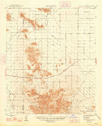
1948 Map of Antelope Peak
USGS Topo · Published 1948About this map
Table Top Mountains dominate the southern portion of this desert landscape at the edge of the Maricopa Indian Reservation. The 1948 survey provides an intricate view of the arid terrain, where the massive Table Top and nearby Antelope Peak rise sharply above the floor of Hidden Valley. Water resources are sparse and critical in this environment, represented by the ephemeral Vekol Wash and scattered improvements like Tanks and several wells that served the area's few inhabitants and livestock. The map traces the boundary between Maricopa and Pinal Counties, capturing a moment when much of the land was managed as part of the Papago Indian Reservation or remained open desert. Small developments along Route 84 show the early influence of highway transit through the Gila River Valley region.
Find a feature on this map
15 named features on this map. Tap any name to fly to it.
Don’t see what you’re looking for? This feature index may not catch every label — zoom into the map to look around manually.
Map Details
Editions of this 1948 Antelope Peak Map
2 editions found

Other maps of this area

1913 · Maricopa
USGS Topo · 1:62,500

1914 · Gila Butte
USGS Topo · 1:62,500

1915 · Maricopa
USGS Topo · 1:62,500

1917 · Gila Butte
USGS Topo · 1:62,500

1922 · Casa Grande
USGS Topo · 1:62,500

1924 · Casa Grande
USGS Topo · 1:62,500

1941 · Vekol Mountains
USGS Topo · 1:62,500

1942 · Silver Reef Mountains
USGS Topo · 1:62,500

1942 · Vekol Mountains
USGS Topo · 1:62,500

1946 · Antelope Peak
USGS Topo · 1:62,500