
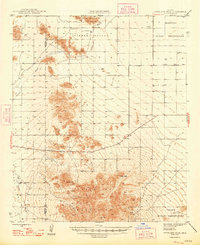
1948 Map of Antelope Peak
USGS Topo · Published 1948About this map
Verde Mountain and the high desert of the Hidden Valley anchor this mid-century survey of the arid borderlands between Maricopa and Pinal Counties. The landscape is defined by the sharp verticality of Antelope Peak and Table Top, rising dramatically from the surrounding desert floor where water management is marked by occasional Well and Tank symbols. These sparse water sources highlight the survival challenges in this environment, which is shared by the Maricopa Indian Reservation in the northeast and the Papago Indian Reservation to the south. The course of Vekol Wash provides the primary drainage through the terrain, winding past Indian Butte and the Papago Buttes. This 1948 edition, with shaded relief added in 1953, offers a clear perspective on the landforms before modern agricultural or residential expansion altered the valley floor.
Find a feature on this map
12 named features on this map. Tap any name to fly to it.
Don’t see what you’re looking for? This feature index may not catch every label — zoom into the map to look around manually.
Map Details
Editions of this 1948 Antelope Peak Map
2 editions found
Other maps of this area

1913 · Maricopa
USGS Topo · 1:62,500

1914 · Gila Butte
USGS Topo · 1:62,500

1915 · Maricopa
USGS Topo · 1:62,500

1917 · Gila Butte
USGS Topo · 1:62,500

1922 · Casa Grande
USGS Topo · 1:62,500

1924 · Casa Grande
USGS Topo · 1:62,500

1941 · Vekol Mountains
USGS Topo · 1:62,500

1942 · Silver Reef Mountains
USGS Topo · 1:62,500

1942 · Vekol Mountains
USGS Topo · 1:62,500

1946 · Antelope Peak
USGS Topo · 1:62,500