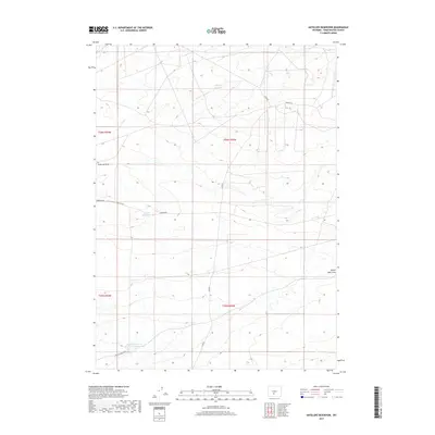
2017 Map of Antelope Reservoir
USGS Topo · Published 2017About this map
Antelope Reservoir sits at the heart of this Sweetwater County landscape, where natural drainage and human engineering converge in an arid high-desert environment. The map details a complex network of ephemeral watercourses and catchments, including Osborne Draw and the distinctively named Little Osborne Lake. In the southern portion of the quadrangle, the Eagles Nest Draw Reservoir Number One anchors the headwaters of Eagles Nest Draw, illustrating the vital importance of water management in this Wyoming interior. The transportation grid is defined by remote access routes and county corridors like Bairol Rd and Osborne Rd, alongside numerous Bureau of Land Management tracks such as Blm Rd 3212. This 2017 survey provides a clear view of the land division and ranching infrastructure typical of the region's vast public lands.
Find a feature on this map
16 named features on this map. Tap any name to fly to it.
Don’t see what you’re looking for? This feature index may not catch every label — zoom into the map to look around manually.
Map Details
Editions of this 2017 Antelope Reservoir Map
This is the sole edition of this map. No revisions or reprints were ever made.
Other maps of this area

1955 · Lander
USGS Topo · 1:250,000

1955 · Casper
USGS Topo · 1:250,000

1958 · Casper
USGS Topo · 1:250,000

1958 · Lander
USGS Topo · 1:250,000

1960 · Battle Spring
USGS Topo · 1:24,000

1960 · Sooner Reservoir
USGS Topo · 1:24,000

1960 · Lost Creek Lake
USGS Topo · 1:62,500

1961 · Lander
USGS Topo · 1:250,000
1961 · Osborne Well
USGS Topo · 1:24,000
1961 · Lost Creek Reservoir
USGS Topo · 1:24,000