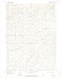
1961 Map of Osborne Well
USGS Topo · Published 1964About this map
The high desert terrain of Sweetwater County is defined here by a series of significant drainages and water-management sites during the early 1960s. The landscape is carved by Osborne Draw and Eagles Nest Draw, which provide natural corridors through the varied elevations. Human impact in this arid environment is evident in the presence of Osborne Well and the Crooked Well Reservoir, critical infrastructure for livestock or resource extraction in the Red Desert region. Evidence of geological exploration is scattered across the quadrangle, notably marked by several Prospects and a Drill hole. The map illustrates the specialized infrastructure required for survival and industry in a territory dominated by Battle Spring Draw and Stratton Draw, where water sources are often seasonal or engineered.
Find a feature on this map
14 named features on this map. Tap any name to fly to it.
Don’t see what you’re looking for? This feature index may not catch every label — zoom into the map to look around manually.
Map Details
Editions of this 1961 Osborne Well Map
2 editions found
Other maps of this area

1955 · Casper
USGS Topo · 1:250,000

1958 · Casper
USGS Topo · 1:250,000

1960 · Battle Spring
USGS Topo · 1:24,000

1960 · Sooner Reservoir
USGS Topo · 1:24,000

1960 · Chicken Spring
USGS Topo · 1:24,000
1961 · Antelope Reservoir
USGS Topo · 1:24,000

1961 · Hadsell Spring
USGS Topo · 1:24,000

1961 · Crooks Peak
USGS Topo · 1:24,000
1961 · Brenton Springs
USGS Topo · 1:24,000

1962 · Casper
USGS Topo · 1:250,000