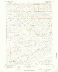
1961 Map of Antelope Reservoir
USGS Topo · Published 1964About this map
Osborne Draw and Eagles Nest Draw define the topography of this high-desert portion of Sweetwater County, where water management was essential for land use in the early 1960s. The landscape is marked by small-scale irrigation and stock water features, including the Antelope Reservoir in the north and the Eagles Nest Draw Reservoir No 1 in the southwest corner. The presence of Little Osborne Lake and these artificial impoundments illustrates the seasonal nature of the drainage systems carving through the arid terrain. This mapping, based on 1960 aerial photography, captures the remote character of the Wyoming basin before modern developments, showing a network of unimproved trails and the precise contours of the high plains drainage basins.
Find a feature on this map
5 named features on this map. Tap any name to fly to it.
Don’t see what you’re looking for? This feature index may not catch every label — zoom into the map to look around manually.
Map Details
Editions of this 1961 Antelope Reservoir Map
2 editions found
Other maps of this area

1955 · Lander
USGS Topo · 1:250,000

1955 · Casper
USGS Topo · 1:250,000

1958 · Casper
USGS Topo · 1:250,000

1958 · Lander
USGS Topo · 1:250,000

1960 · Battle Spring
USGS Topo · 1:24,000

1960 · Sooner Reservoir
USGS Topo · 1:24,000

1960 · Lost Creek Lake
USGS Topo · 1:62,500

1961 · Lander
USGS Topo · 1:250,000
1961 · Osborne Well
USGS Topo · 1:24,000
1961 · Lost Creek Reservoir
USGS Topo · 1:24,000