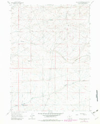
1961 Map of Antelope Reservoir
USGS Topo · Published 1982About this map
Antelope Reservoir and the drainage patterns of the Wyoming high desert define this portion of Sweetwater County. The map documents a landscape primarily shaped by seasonal water management and resource extraction, with ephemeral water bodies like Little Osborne Lake and Eagles Nest Draw Reservoir No 1 providing critical water sources in an otherwise arid environment. The presence of several prospects in the northeast suggests early-stage mineral exploration during the mid-20th century. The terrain is marked by significant topographical features such as Osborne Draw and Eagles Nest Draw, which dictate the local hydrology. This 1961 record, later updated in the early 1980s, captures the sparse ranching and mining infrastructure that characterized this remote section of the state during a period of expanding land use.
Find a feature on this map
6 named features on this map. Tap any name to fly to it.
Don’t see what you’re looking for? This feature index may not catch every label — zoom into the map to look around manually.
Map Details
Editions of this 1961 Antelope Reservoir Map
2 editions found
Other maps of this area

1955 · Lander
USGS Topo · 1:250,000

1955 · Casper
USGS Topo · 1:250,000

1958 · Casper
USGS Topo · 1:250,000

1958 · Lander
USGS Topo · 1:250,000

1960 · Battle Spring
USGS Topo · 1:24,000

1960 · Sooner Reservoir
USGS Topo · 1:24,000

1960 · Lost Creek Lake
USGS Topo · 1:62,500

1961 · Lander
USGS Topo · 1:250,000
1961 · Osborne Well
USGS Topo · 1:24,000
1961 · Lost Creek Reservoir
USGS Topo · 1:24,000