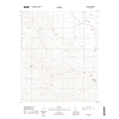
2020 Map of Antelope Ridge
USGS Topo · Published 2020About this map
Antelope Ridge and the surrounding high country of Grant County are defined by a network of deep drainage systems and ranching infrastructure. This high-desert landscape is carved by substantial geological features such as Shields Canyon, Rock House Canyon, and Foster Canyon, all feeding toward the Duck Cr and Sycamore Cr watersheds. The terrain is punctuated by prominent elevations including Black Mtn and Bald Knoll, while human activity is evidenced primarily through water management for livestock. Numerous tanks, such as Mud Flat Tank, Pitts Pasture Tank, and Tadpole Tank, are scattered across the townships, reflecting the essential role of water rights in this arid environment. Genealogy researchers will find the Stout Cem near the eastern boundary, a singular point of historical burial in an otherwise sparse wilderness. Local ranching access is maintained via remote routes like Black Mountain Rd and Norris Rd.
Find a feature on this map
54 named features on this map. Tap any name to fly to it.
Don’t see what you’re looking for? This feature index may not catch every label — zoom into the map to look around manually.
Map Details
Editions of this 2020 Antelope Ridge Map
This is the sole edition of this map. No revisions or reprints were ever made.
Other maps of this area

1910 · Mogollon
USGS Topo · 1:125,000

1912 · Mogollon
USGS Topo · 1:125,000

1954 · Silver City
USGS Topo · 1:250,000

1954 · Clifton
USGS Topo · 1:250,000

1957 · Clifton
USGS Topo · 1:250,000

1958 · Silver City
USGS Topo · 1:250,000

1958 · Clifton
USGS Topo · 1:250,000

1959 · Steeple Rock
USGS Topo · 1:62,500

1959 · Cliff
USGS Topo · 1:62,500

1962 · Silver City
USGS Topo · 1:250,000