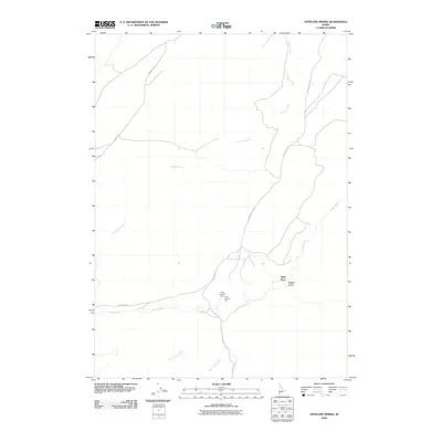
2010 Map of Antelope Spring
USGS Topo · Published 2010About this map
Castle Creek and its many tributaries, including Horse Thief Creek and Alder Creek, carve through this Owyhee County landscape in the early 21st century. The map highlights a remote ranching and mining environment where the Spiry Place stands as a primary landmark alongside significant mining claims such as Amie Number One and Amie Number Two. Transportation is limited to rugged tracks like Alder Creek Rd and Triangle Rd, which follow the natural contours of the drainages and ridges. The presence of features like Hogpen Gulch and Buckaroo Creek reflects the region's enduring livestock heritage and the localized naming conventions of the Idaho backcountry. This map preserves the spatial relationship between isolated homestead sites and the high-desert water sources that define settlement patterns in this part of the state.
Find a feature on this map
12 named features on this map. Tap any name to fly to it.
Don’t see what you’re looking for? This feature index may not catch every label — zoom into the map to look around manually.
Map Details
Editions of this 2010 Antelope Spring Map
This is the sole edition of this map. No revisions or reprints were ever made.
Other maps of this area

1892 · Bisuka
USGS Topo · 1:125,000

1892 · Silver City
USGS Topo · 1:125,000

1894 · Bisuka
USGS Topo · 1:125,000

1894 · Silver City
USGS Topo · 1:125,000

1898 · Silver City
USGS Topo · 1:125,000

1948 · Castle Butte
USGS Topo · 1:24,000

1949 · Oreana
USGS Topo · 1:62,500
1949 · Oreana
USGS Topo · 1:24,000
1950 · Oreana
USGS Topo · 1:24,000

1955 · Jordan Valley
USGS Topo · 1:250,000