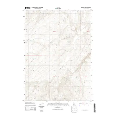
2013 Map of Antelope Spring
USGS Topo · Published 2013About this map
Spiry Place sits as a lonely human landmark amidst the network of drainage systems in Owyhee County, where the high desert landscape is defined by its water sources and rugged transit routes. This 2013 survey highlights the intricate hydrology of the region, anchored by Antelope Spring and numerous seasonal flows such as Buckaroo Cr, Horse Thief Cr, and Castle Cr. The naming conventions found here, from Hogpen Gulch to the steep Bachman Grade, reflect a history of ranching and early mountain passage. Long-established tracks like Triangle Rd and Alder Creek Rd connect these remote coordinates, tracing the same essential paths used for decades to navigate the canyons and creek beds of the high Owyhee country.
Find a feature on this map
18 named features on this map. Tap any name to fly to it.
Don’t see what you’re looking for? This feature index may not catch every label — zoom into the map to look around manually.
Map Details
Editions of this 2013 Antelope Spring Map
This is the sole edition of this map. No revisions or reprints were ever made.
Other maps of this area

1892 · Bisuka
USGS Topo · 1:125,000

1892 · Silver City
USGS Topo · 1:125,000

1894 · Bisuka
USGS Topo · 1:125,000

1894 · Silver City
USGS Topo · 1:125,000

1898 · Silver City
USGS Topo · 1:125,000

1948 · Castle Butte
USGS Topo · 1:24,000

1949 · Oreana
USGS Topo · 1:62,500
1949 · Oreana
USGS Topo · 1:24,000
1950 · Oreana
USGS Topo · 1:24,000

1955 · Jordan Valley
USGS Topo · 1:250,000