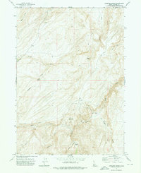
1972 Map of Antelope Spring
USGS Topo · Published 1976About this map
Amie No 1 and Amie No 2 mines stand as evidence of mineral exploration in this high-desert landscape of Owyhee County. The terrain is defined by a dense network of drainages including Castle Creek, Buckaroo Creek, and Alder Creek, which supported a sparse collection of ranching outposts such as Spiry Place and Carothers Place. The presence of Rock Corral Spring and Antelope Spring highlights the critical importance of water sources in an area primarily accessible by a Jeep Trail or the steep Bachman Grade. This 1970s survey captures the region just as the Boise Meridian serves as the primary longitudinal reference, illustrating a remote ranching and prospecting economy where named landmarks like Hogpen Gulch provided essential orientation for local cattlemen and miners moving through the sagebrush hills.
Find a feature on this map
23 named features on this map. Tap any name to fly to it.
Don’t see what you’re looking for? This feature index may not catch every label — zoom into the map to look around manually.
Map Details
Editions of this 1972 Antelope Spring Map
This is the sole edition of this map. No revisions or reprints were ever made.
Other maps of this area

1892 · Bisuka
USGS Topo · 1:125,000

1892 · Silver City
USGS Topo · 1:125,000

1894 · Bisuka
USGS Topo · 1:125,000

1894 · Silver City
USGS Topo · 1:125,000

1898 · Silver City
USGS Topo · 1:125,000

1948 · Castle Butte
USGS Topo · 1:24,000

1949 · Oreana
USGS Topo · 1:62,500
1949 · Oreana
USGS Topo · 1:24,000
1950 · Oreana
USGS Topo · 1:24,000

1955 · Jordan Valley
USGS Topo · 1:250,000