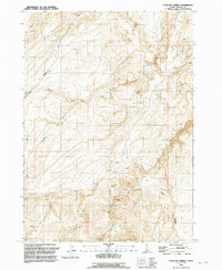
1992 Map of Antelope Spring
USGS Topo · Published 1992About this map
Mining operations and ranching infrastructure characterize this high-desert landscape in Owyhee County, surveyed in the late 20th century. The intricate topography is marked by numerous Prospects and identified claims such as Amie No 1 Amie No 2, indicating a legacy of mineral exploration in the hills surrounding Hogpen Gulch. The sparse settlement pattern relies heavily on scattered water sources, including Antelope Spring, Buckaroo Spring, and the perennial Alder Springs, which support livestock at sites like Rock Corral.
Find a feature on this map
21 named features on this map. Tap any name to fly to it.
Don’t see what you’re looking for? This feature index may not catch every label — zoom into the map to look around manually.
Map Details
Editions of this 1992 Antelope Spring Map
This is the sole edition of this map. No revisions or reprints were ever made.
Other maps of this area

1892 · Bisuka
USGS Topo · 1:125,000

1892 · Silver City
USGS Topo · 1:125,000

1894 · Bisuka
USGS Topo · 1:125,000

1894 · Silver City
USGS Topo · 1:125,000

1898 · Silver City
USGS Topo · 1:125,000

1948 · Castle Butte
USGS Topo · 1:24,000

1949 · Oreana
USGS Topo · 1:62,500
1949 · Oreana
USGS Topo · 1:24,000
1950 · Oreana
USGS Topo · 1:24,000

1955 · Jordan Valley
USGS Topo · 1:250,000