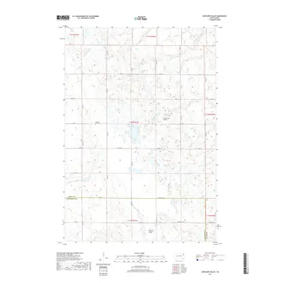
2017 Map of Antelope Valley
USGS Topo · Published 2017About this map
The Coteau des Prairies plateau dominates this northeastern South Dakota landscape, characterized by a high concentration of small wetlands and glacial depressions. Within this undulating terrain, the Antelope Valley and its namesake Antelope Valley Cem serve as primary landmarks for local history researchers and genealogists tracing families in this rural corridor. The map reveals a strictly rectangular grid of county roads, such as Co HWY 14 and Co HWY 7, which navigate around natural water features like Myers Lake and the Twin Lakes at the northern boundary. Straddling the line between Grant and Codington counties, the area's agricultural layout is defined by the Public Land Survey System, with township and range lines like t120n r51w providing the framework for the region's isolated farmsteads and field patterns.
Find a feature on this map
24 named features on this map. Tap any name to fly to it.
Don’t see what you’re looking for? This feature index may not catch every label — zoom into the map to look around manually.
Map Details
Editions of this 2017 Antelope Valley Map
This is the sole edition of this map. No revisions or reprints were ever made.
Other maps of this area

1953 · Milbank
USGS Topo · 1:250,000

1958 · Milbank
USGS Topo · 1:250,000

1970 · Summit
USGS Topo · 1:24,000

1970 · Still Lake SE
USGS Topo · 1:24,000

1970 · Marvin
USGS Topo · 1:24,000

1970 · Still Lake NE
USGS Topo · 1:24,000

1971 · Corona
USGS Topo · 1:24,000

1973 · Twin Brooks
USGS Topo · 1:24,000

1973 · Stockholm
USGS Topo · 1:24,000
1973 · South Shore
USGS Topo · 1:24,000