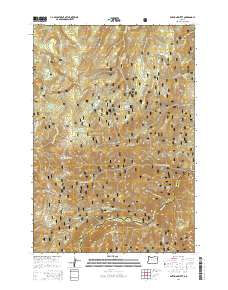
2014 Map of Anthony Butte
USGS Topo · Published 2014About this map
Indiana Mine sits high on the western slopes of the Whitman National Forest, a reminder of the prospecting history that once defined these ridges. The landscape is characterized by high-elevation meadows and water sources like Friday Meadow and High Summit Spring, which feed into the East Fork Grande Ronde River. The terrain drops sharply toward the south, where the Anthony Cr carves through the Anthony Gorge before crossing the Union County and Baker County line. This 2014 survey reveals a transition from these dramatic canyons to the high flats near Gorham Butte. A network of Forest Service routes, such as the Indiana Mine Rd and High Mountain Rd, provides access to these remote reaches, connecting landmarks like Anthony Butte and Sand Flats.
Find a feature on this map
44 named features on this map. Tap any name to fly to it.
Don’t see what you’re looking for? This feature index may not catch every label — zoom into the map to look around manually.
Map Details
Editions of this 2014 Anthony Butte Map
This is the sole edition of this map. No revisions or reprints were ever made.
Other maps of this area

1901 · Sumpter
USGS Topo · 1:125,000

1953 · Pendleton
USGS Topo · 1:250,000

1955 · Canyon City
USGS Topo · 1:250,000

1956 · Pendleton
USGS Topo · 1:250,000

1959 · Canyon City
USGS Topo · 1:250,000

1965 · Limber Jim Creek
USGS Topo · 1:24,000

1965 · Anthony Butte
USGS Topo · 1:24,000
1965 · Glass Hill
USGS Topo · 1:24,000
1965 · Tucker Flat
USGS Topo · 1:24,000

1965 · Little Beaver Creek
USGS Topo · 1:24,000