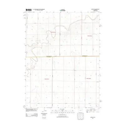
2013 Map of Anton SE
USGS Topo · Published 2013About this map
The Arikaree River and its tributary, the North Fork Arikaree River, dominate this landscape on the High Plains along the boundary of Washington Co and Kit Carson Co. The river system exhibits a highly serpentine pattern as it cuts through the flat terrain, creating a complex series of bends and oxbows. This 2013 survey illustrates the sparse, grid-based road network characteristic of eastern Colorado ranching and agricultural country, with routes like Co Road HH, Co Road 3, and Co Road PP defining property lines and section boundaries. The map provides a precise look at the land division under the Public Land Survey System, including t005s r051w and t006s r051w, showing how rural infrastructure adapts to the natural flow of the watercourses.
Find a feature on this map
21 named features on this map. Tap any name to fly to it.
Don’t see what you’re looking for? This feature index may not catch every label — zoom into the map to look around manually.
Map Details
Editions of this 2013 Anton SE Map
This is the sole edition of this map. No revisions or reprints were ever made.
Other maps of this area

1954 · Limon
USGS Topo · 1:250,000

1957 · Limon
USGS Topo · 1:250,000

1958 · Limon
USGS Topo · 1:250,000

1977 · Thurman
USGS Topo · 1:24,000

1977 · Arickaree
USGS Topo · 1:24,000

1977 · Anton SE
USGS Topo · 1:24,000

1977 · Cope SW
USGS Topo · 1:24,000
1978 · Anton
USGS Topo · 1:24,000
1978 · Cope NW
USGS Topo · 1:24,000

1979 · Flagler NW
USGS Topo · 1:24,000