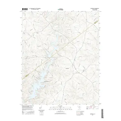
2017 Map of Antreville
USGS Topo · Published 2017About this map
Antreville serves as the central hub of this northern Abbeville County landscape, situated where the Anderson Co and Abbeville Co border divides the countryside. The geography is dominated by the intricate, finger-like shorelines of Lake Secession and Secession Lake, which are formed by the impoundment of the Rocky River. This 2017 study illustrates a rural network of family and community landmarks, evidenced by numerous burial sites including the Carswell Baptist Cem and Hall Cromer Cem. The map provides a detailed view of the local drainage systems, tracing the paths of Henkoop Creek, Bear Cr, and First Cr as they feed into the larger river basin. Roadways like Airline Rd and Flat Rock Rd connect scattered homesteads and the small settlement of Leverett, reflecting a region defined by its water-access points and longstanding agricultural roots.
Find a feature on this map
106 named features on this map. Tap any name to fly to it.
Don’t see what you’re looking for? This feature index may not catch every label — zoom into the map to look around manually.
Map Details
Editions of this 2017 Antreville Map
This is the sole edition of this map. No revisions or reprints were ever made.
Other maps of this area

1892 · Abbeville
USGS Topo · 1:125,000

1893 · Elberton
USGS Topo · 1:125,000

1948 · Abbeville West
USGS Topo · 1:24,000

1949 · Abbeville
USGS Topo · 1:24,000

1954 · Greenville
USGS Topo · 1:250,000

1958 · Greenville
USGS Topo · 1:250,000

1964 · Iva
USGS Topo · 1:24,000

1964 · Antreville
USGS Topo · 1:24,000

1964 · Lowndesville
USGS Topo · 1:24,000

1964 · Saylors Crossroads
USGS Topo · 1:24,000